 Quality score
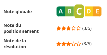
Panoramax offers a Quality Score for each picture in its web viewer. It allows easy map filtering and comprehensive display of high-quality pictures availability.
The grade is shown to users as a A/B/C/D/E score (A is the best, E the worst), and shown graphically through this scale (inspired by Nutri-Score):

Score computation
Quality score is based on two indicators:
- GPS position accuracy: how precisely the GPS coordinates are set, in meters. This is 1/5 of the score.
- Horizontal pixel density: how many pixels we have on horizon per field of view degree. This is 4/5 of the score.
They are displayed through web viewer in picture metadata popup:

Info
We know that this is a pretty simple indicator. Many other information could be taken into account (blurriness, light...) and may be used in the future. We started with something simple to make the quality score available on as many pictures as possible. You can come and help us to make this happen sooner
GPS position accuracy
This indicator allows to know if we can rely or not on GPS position, based on its precision. It is expressed as a decimal value in meters. The grade is a 5-star rating, and is applied based on these values:
| GPS Accuracy | Grade |
|---|---|
| <= 1 m | 5/5 |
| <= 2 m | 4/5 |
| <= 5 m | 3/5 |
| <= 10 m | 2/5 |
| > 10 m or unknown | 1/5 |
The value is read from picture EXIF metadata. We rely on the following tags:
- Horizontal positioning error (
Exif.GPSInfo.GPSHPositioningErrororXmp.exif.GPSHPositioningError) : expected positioning error in meters. - Dilution of precision (
Exif.GPSInfo.GPSDOPorXmp.exif.GPSDOP) : indicator of expected precision on coordinates (<= 1 means good precision for the sensor, >= 5 is not good, more info on Wikipedia). - Is the GPS differential (
Exif.GPSInfo.GPSDifferentialorXmp.exif.GPSDifferential) : indicates if GPS sensor is using Differential GPS or not. If yes, we expect a better precision.
These are used to define a precision value in meters. If none of these tags are set, we also rely on a default value for several camera vendors (based on Make and Model EXIF tags).
So, to get a good grade on GPS precision, you can (in order):
- Set a precise Horizontal positioning error
- Set a value for Differential GPS and/or Dilution of precision
- Set values for Make and Model if you use a common camera
Info
If you find the shown value not reflecting the real precision of your GPS sensor, feel free to contact us with an example link. We tried to make precision estimates on a large set of cameras, but we may have missed some
Horizontal pixel density
This indicator allows to have an idea of how high the picture resolution is, independently of its field of view (360° or classic picture). The formula is: picture width in pixels / field of view in degrees. We have in result a number of pixels per FOV degree. The grade is a 5-star rating, and is applied based on these values:
| Grade | Density for 360° | Density for non 360° |
|---|---|---|
| 5/5 | >= 30 px/deg | Not possible |
| 4/5 | >= 15 px/deg | >= 30 px/deg |
| 3/5 | < 15px/deg | >= 15px/deg |
| 2/5 | Not possible | >= 10 px/deg |
| 1/5 | Unknown value | < 10 px/deg or unknown value |
Info
A different rating is applied for 360°, as they offer a nicer user experience on web viewer. Note that if you're a technical reuser, the API offers raw values for each indicator, allowing you to do your own custom rating.
The value is computed from picture width in pixels, and some EXIF metadata. We rely on the following tags:
- Focal length (
Exif.Image.FocalLengthorExif.Photo.FocalLength): distance in millimeters between the nodal point of the lens and the camera sensor. - Focal length (35mm equivalent) (
Exif.Image.FocalLengthIn35mmFilmorExif.Photo.FocalLengthIn35mmFilm): same as focal length, but in 35mm film equivalent. - Make and model (
Exif.Image.MakeandExif.Image.Make): camera model, which is used to find camera sensor width. - Projection type (for 360° pictures,
Xmp.GPano.ProjectionType): to mark a picture as 360°
Based on these information, we are able to compute the field of view (how wide the camera can look horizontally).
As these information are hard to deduce, you may carefully set all of them in EXIF metadata.
Info
If you have pictures with an unknown value for this grade, it's probably because we miss information on your camera model. Make sure your pictures have required information, and contact us with the camera sensor width so we can add it in our listing.
